The inner region of the Amazon estuary is studded with islands forming a landscape similar to a delta. The largest island is Marajó, of nearly 40,000 km2, followed by Caviana, Mexiana and Gurupá. These and other islands form small archipelagoes, the most important being Bailique, Caviana, Marajó and the Pará River. The archipelagoes of Caviana and Mexiana embrace an area larger than 6,000 km2 and are separated by the Canal Perigoso, which is shallow and dangerous to navigate due to the high exposure to oceanic winds and waves. Caviana Island was split into two parts in historic times (1850) by the tidal bore, locally called pororoca, which is a large wave generated over shallow areas in the Amazon estuary. The islands of the inner Amazon delta are low and flat. The western half of Marajó Island has elevations up to 15 meters, whereas the eastern half is lower and subject to extensive flooding during the rainy season.
There are large savannas on eastern Marajó, the result of both natural processes and fires set by humans since indigenous times. Western Marajó is covered mostly by forest, much of which is invaded by daily tides. This type of forest is called tidal várzea forest and, in contrast to the seasonally inundated savannas of eastern Marajó, is flooded on a daily basis. The savanna regions are flooded five to seven months annually by local rainwater. Average annual precipitation of Marajó varies, according to exact location, from approximately 2,300 to 3,400 mm, with the highest values in the east. Peak rainfall occurs between February and April. Marajó, with a population of 250,000, is the only island of the estuary’s archipelagoes that has cities. The other islands have cattle ranches, small farms, or villages whose economies are based on fishing and açaí (Euterpe oleracea) fruit and palmito extraction.
The savannas, or campos, are in depressions with relatively little outward drainage and several permanent lakes are formed. Lago Arari is the largest. Tides also impede outward drainage of the savannas. During the rainy season the savanna lakes can be joined by one huge sheet of water. Artificial channels have been dug in the savannas to facilitate transportation between Belém and Macapá and also to decrease flooding times in order to increase cattle production. The largest is the Canal da Tartaruga, which was constructed in the first half of the twentieth century to connect Lago Arari to the north. The artificial channels are easily colonized by aquatic plants and filled with sediments. There is a pronounced dry season on Marajó between October and November and many lakes can become completely dry in some years. Artificial dams have been built by the farmers or as government projects to avoid complete drainage of the lakes. The elevation of the campos determines flooding times and the predominant vegetation type. Approximately 70% of the campos are subject to seasonal inundation. Common campo grasses subject to flooding include species of the genera Oryza, Echinochloa and Panicum; sedges (Cyperus) are also abundant. Waterlogged areas are often dominated by the miriti palm (Mauritia flexuosa) and aninga (Montrichardia arborescens), a giant herbaceous plant. Cattle ranching, which has existed in this region since the 1700s, is the most important economic activity of the campos.
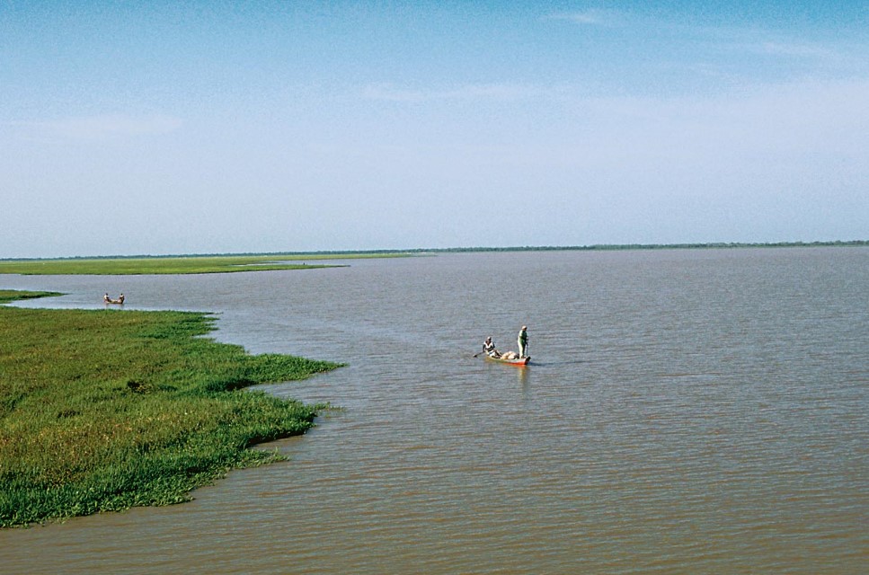
The most important fisheries are located in lakes that are exploited mostly during the dry season. The largest, Lago Arari, at 3,600 km2, is 6 meters above sea level and has a maximum depth of only about 5 meters. The average annual water level fluctuation of Lago Arari is 3 meters. Fishermen of Marajó have traditionally also been cowboys and farmers, as fishing was used to supplement low salaries paid by ranch owners. Today professional fishermen dominate the fisheries during the low water season. Ice boats stationed at nearby villages and cities buy catches that are then transported mostly to Belém. Most fish are taken with gillnets and cast nets when fish are isolated in small pools of the shallow lakes. Waters are sufficiently shallow year-round, however, to permit the use of cast nets. Harpoons and line-and-hook are also used commercially in the lakes. Small beach seines have been used in the past but are now prohibited. In the past, the most valuable speices were tucunaré (Cichla spp.), apaiari (Astronotus spp.) and pirarucu (Arapaima gigas). Today tamoatá (Hoplosternum littorale), a medium-sized armored catfish, accounts for more than 60% of the annual fish catch. Traíra (Hoplias malabaricus), cachorro do padre (Parauchenipterus sp.) and aracu (Leporinus and Schizodon) are other important species captured in Marajó lakes. Professional and subsistence fishermen have reported a rapid decline in the tamoatá catch and there is now a closed season for the species between January and May.
The várzea tidal forest found on the numerous islands of the estuary is also important to fish ecology and indirectly to some fisheries, but this habitat has been little studied scientifically. The total area of tidal forests flooded is is greater than 20,000 km2. These forests are inundated for 8 to 12 hours daily, when fishes move into them to feed, seek shelter or breed. The most important economic activity in the tidal várzea forests is timber. The main species exploited are virola or ucuúba (Virola surinamensis), sumaúma (Ceiba pentandra), assacú (Hura crepitans), anani (Symphonia globulifera) andiroba (Carapa guianensis), cedro-branco (Cedrela sp.), sucupira (Diplotropis sp.) and tamaquaré (Caraipa densifolia). Palms are often dominant in the tidal forests, especially açaí (Euterpe oleraceae) and (Mauritia flexuosa).
The contact zone between the Tocantins River River and the Amazon RiverAmazon River centers on the Pará River and this is an area of relatively high phytoplankton production. The Amazon River supplies nutrients and the relatively clear waters of the Tocantins River River allow for increased transparency. These two factors lead to increased photosynthesis for phytoplankton, the basis of a food chain on which several commercial shrimp and fish species depend.
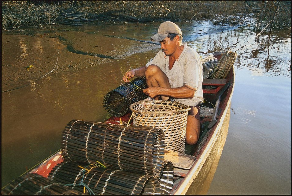
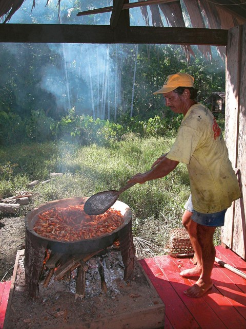
Shrimp are the most important commercial species. The matapi is a small cylindrical wicker shrimp trap with two openings. The trap is usually constructed from the palm stems of the jupati (Raphia taedigera) and used to catch shrimp. The traps are baited with manioc or babaçu (Attalea speciosa) palm nut flour. The matapi fishery is found in most of the inner delta of the Amazon River and especially along the Pará River, Lower Tocantins, Estreitos de Breves and Gurupá. The matapi trap accounts for 80% of the shrimp catch in the Pará River, the most important estuary area for freshwater shrimp. Matapi shrimp fisheries are based on a large number of canoes belonging to thousands of local inhabitants living in the tidal zone. A single fisherman might use dozens of matapi traps. Shrimp are captured mainly at night, then boiled and salted and sold to urban centers. There are few accurate data on shrimp catches.
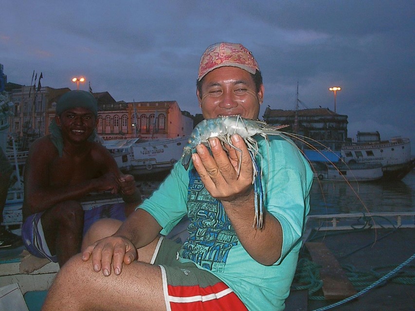
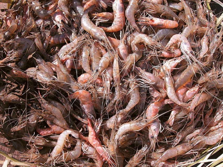
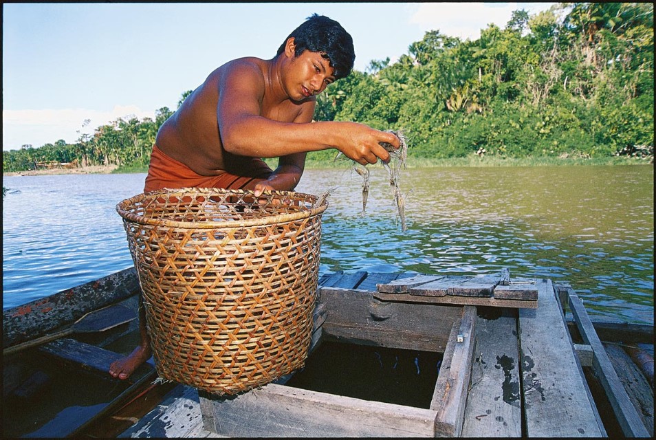
There are two important shrimp species exploited in the estuary channel system and várzea tidal forests of the inner delta: the Amazon River prawn or camarão cascudo (Macrobrachium amazonicum) and the painted river prawn or big-claw river shrimp, or pitú (Macrobrachium carcinus), as it is called locally. Matapi shrimp catches are highest when water levels are falling in May and June in the Lower Tocantins River and Pará River. Interestingly, in the Amazon River near Almeirim and Gurupá Island most shrimp are captured between August and September. The big-claw river shrimp fishery is concentrated between Gurupá Island and the Amazon River mouth. The single most important fishing area for this shrimp species is near the city of Afuá, at the northwestern border of Marajó Island. Macrobrachium rosenbergii is an exotic shrimp species from Malaysia that is used in aquaculture. It escaped from local tanks and has now colonized areas of the Amazon estuary that are invaded by salt water. Its impact on local shrimp populations has not been investigated.
-
Marajó y Delta Interior 1
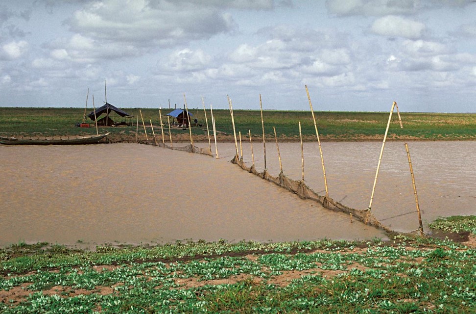
A simple fish weir that blocks the Canal da Tartargua near Lago Arari in the savannas of northeastern Marajó Island. Department – Country: Pará – Brazil Main Basin – Sub Basin: stuary – South Amazon Estuary Photographer: Michael Goulding
-
Marajó y Delta Interior 2
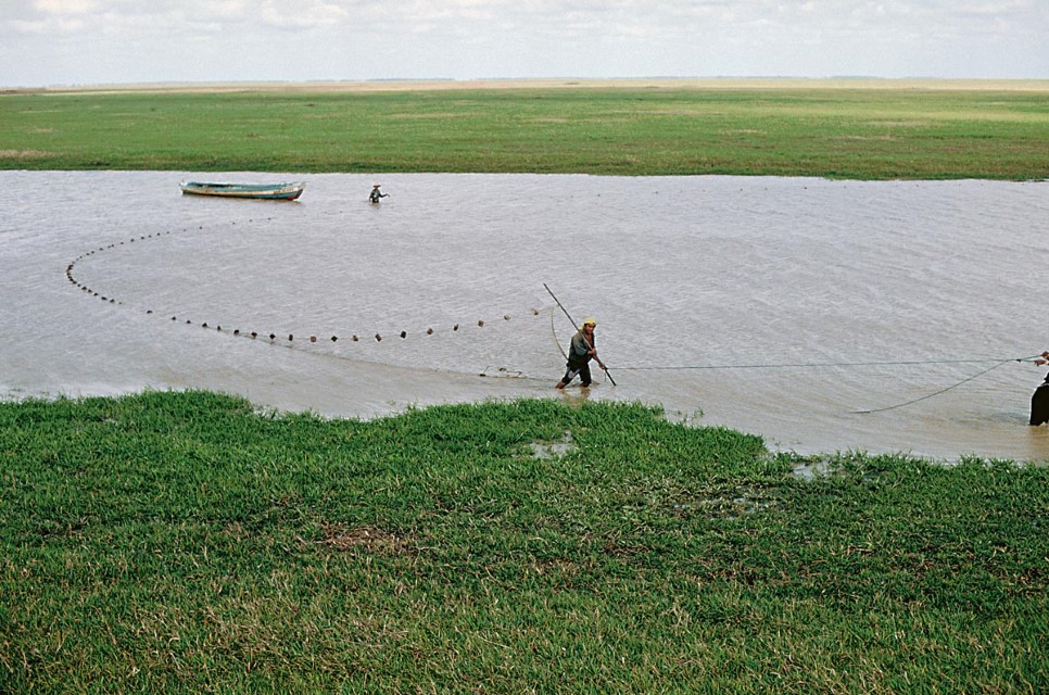
Gill nets used as a seine in the Canal da Tartaruga near Lago Arari in the savannas of northeastern Marajó Island. Department – Country: Pará – Brazil Main Basin – Sub Basin: stuary – South Amazon Estuary Photographer: Michael Goulding
-
Marajó y Delta Interior 3
Macrobrachium rosenbergii, an exotic species. Department – Country: Pará – Brazil Photographer: Ronaldo Barthem
-
Marajó y Delta Interior 4
Fishermen in Lago Ararí of Marajó Island. The lake is filled by local rainwater and annual water level fluctuation is approximately 3 meters, with maxima of 5 meters recorded. Department – Country: Pará – Brazil Main Basin – Sub Basin: Estuary – South Amazon Estuary Photographer: Michael Goulding
-
Marajó y Delta Interior 5
Matapí shrimp trap constructed from jupati (Raphia taedigera) palm. The traps are baited to attract shrimp. Department – Country: Roraima – Brazil Main Basin – Sub Basin: Negro – Branco Main Stem Photographer: Luiz Claudio Marigo
-
Marajó y Delta Interior 6
Boiling estuary shrimp (Macrobrachium amazonicum) in saltwater brine. Department – Country: Pará – Brazil Main Basin – Sub Basin: Amazon Main Stem – Eastern Amazon Main Stem Photographer: Luiz Claudio Marigo
-
Marajó y Delta Interior 7
Shrimp (Macrobrachium amazonicum) from freshwaters of the estuary. Department – Country: Pará – Brazil Main Basin – Sub Basin: Amazon Main Stem – Eastern Amazon Main Stem Photographer: Luiz Claudio Marigo
-
Marajó y Delta Interior 8
Shrimp (Macrobrachium amazonicum), the most common crustacean captured in the freshwaters of the estuary. Department – Country: Roraima – Brazil Main Basin – Sub Basin: Negro – Branco Main Stem Photographer: Luiz Claudio Marigo
CONTEXT
The Andes
Cataratas
Floodplain or Várzea
River Mouth Bays
River Channel
Estuary & Amazon Coast
Marajó and Inner Delta
