The lower courses of many Amazonian clearwater and blackwater rivers are greatly expanded in width and form what have been commonly termed “mouth-bays.” Mouth-bay widths are usually not proportional to drainage basin area or to discharge. These lakelike stretches of the rivers are drowned valleys are thought to have been formed by a combination of faulting and excavation during Pleistocene ice age periods when sea levels were lower. Lower sea levels caused rivers to run faster and deepen their beds. The rivers that carried huge quantities of sediments, such as the Amazon River and Madeira River, have subsequently largely filled any Pleistocene excavations. In contrast, the clearwater and blackwater tributaries were not filled because of their minimum sediment loads. The lower courses of many clearwater and blackwater tributaries are now also naturally dammed during parts of the year by relatively higher river levels of the main stems.
Terra firme bluffs often border mouth-bays and make them look like artificial reservoirs. Floodplains are usually narrow but can become large above mouth-bays, such as in the Negro River, where there are archipelagoes. Islands above mouth-bays usually represent a sedimentation zone where river current is slowed by the backwater effect of the main stems.
Although the mouth-bays are flow-through systems, in some cases water can be retained for about half the year because of reduced currents. Nutrient levels are relatively low. Despite low nutrient levels, phytoplankton production can be high in some clearwater rivers such as the Tapajós River because of good water transparency. The density and biomass of the benthos arthropod fauna is generally low in mouth-bays and that of fish may be as well though it has been little investigated. Plankton can accumulate near the confluence of mouth-bays and the main stems into which they flow and these areas often have several specialized phytoplanktivorous and zooplanktivorous fish species. Mouth-bay plankton is also discharged into the turbid rivers where it is thought to be used by arthropod and fish communities. Despite low nutrient levels there are also seasonal phytoplankton blooms in the clearwater mouth-bays.
The largest mouth-bays in the Amazon are those of the three largest clearwater rivers that drain the Brazilian Shield. From east to west these are the Tocantins River, Xingu River and Tapajós River. Mouth-bays range in length from 8 to 150 km and in width from 2 to 15 km. Water depths are usually less than 20 meters. The largest blackwater mouth-bay is that of the Negro River in front of Manaus. From about the mouth of the Madeira River to the Colombian border there are numerous smaller blackwater mouth-bays, such as those of the Tefé River and Coari River.
In permanent lake environments and the ocean, fishes are usually grouped by where they live in the water column and in relation to shore zones. Pelagic fishes live in open waters at various depths, whereas benthic, or demersal, fishes live on or near the bottom. Because most lakes in the Amazon are found on floodplains that are subject to radical changes in water level, the above groupings do not work well. Mouth-bays, however, represent an exception and mapará (Hypophthalmus) catfishes are common commercial species in these habitats, where they feed on phytoplankton and zooplankton. The Tocantins River has been by far the most important mouth-bay fished for mapará, followed by the Xingu River and Tapajós River. Before Tucuruí Dam was constructed mapará fisheries were confined to the area below the impoundment. Now there are also relatively large mapará fisheries in the 2,400 km2 reservoir.
Mapará fisheries of the Lower Tocantins use mostly nets and traps. The pari trap is a type of fence made from palm stems that is used in the Lower Tocantins where tides are at least 1 meter. The pari is placed across small streams to prevent fish from leaving during low tides. Both shrimp and fish are taken behind the fences. The matapi trap is commonly used along sandy beaches to catch shrimp and fish. Gillnets are used both in the Lower Tocantins and in the dam reservoir to capture mapará. This fish form schools not only to migrate upstream but also while feeding on plankton. Schooling offers these pelagic fishes more protection from predators, such as dolphins, but also makes them more vulnerable to fishermen.
The cacuri, a large weir, is perhaps the most unusual mapará fishery of the Tocantins River. This weir is essentially a large fence that corrals fish into two heart-shaped traps at either end. The weirs are placed along the banks of the Lower Tocantins. Migratory mapará schools are the main target of cacuri fisheries. An interesting symbiosis has evolved between boto dolphins (Ignia geoffrensis) and cacuri fishermen. Dolphins herd migratory schools into the weirs and in return fishermen reward the botos with fish.
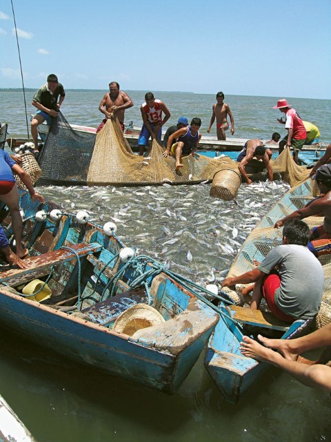
Mapará fisheries of the Lower Tocantins have been operating since the nineteenth century and Cametá has been the main port. Mapará have traditionally been salted for sale in Belém but today most fish is sold fresh. Mapará fisheries became more specialized in the first half of the twentieth century. Fishermen developed a technique called bloqueio, essentially a purse seine. The bloqueio technique employs two 200 to 500 meter nets, 12 to 16 meters in height with 4 cm mesh. Each net is carried in a separate canoe. A mapará school is first located by a fisherman who employs a swordlike device called the tala, which is a flat stick 2.5 to 3 meters long made from the stem of the yarina palm (Phytelephas macrocarpa). From the bow of the canoe the fisherman paddles with one hand and from time to time cuts half-circles in the water with the tala. With the use of the tala the swimming movements of mapará can be felt and the fisherman attempts to ascertain the extent, density and center of the school. Once a mapará school is found, the tala fisherman signals the fishermen in the other canoes to place the nets in the water. After the two nets meet, six to eight fishermen then dive at various positions so that the bottoms of the nets are retrieved to the surface to form a large bag in which the fish are trapped. Mapará are removed with baskets. A mapará bloqueio fishing crew usually has about 30 fishermen and 8 tons of fish can be captured in a single operation.
During the 1970s, attempts were made to industrialize mapará fisheries of the Tocantins River. Most mapará was exported to the United States. In 1974 and 1975, mapará was the fourth most important fish group exported from the state of Pará. Cametá was the most important mapará port, where the species accounted for 40% of the total fish catch in Cametá’s catch, or 1,000 tons.
Mapará schools are also fished in the Xingu River and Tapajós River mouth-bays. Local fishermen of the Tapajós River report that mapará was abundant in the 1960s and early 1970s, but large-scale gold mining operations in the middle course of the river destroyed fish populations because of the huge quantities of sediments discharged into the system. The sediments greatly increased turbidity and this caused a crash in phytoplankton and subsequently fish production. Although gold mining has plummeted since the early 1990s mapará populations still do not appear to have recovered in the Tapajós River.
-

Bahía de las desembocaduras 1
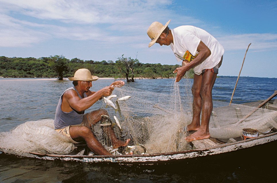
Fishing a beach with gill nets in the rio Tapajós mouth-bay during the low water period. Photographer: Michael Goulding
-

Bahía de las desembocaduras 02
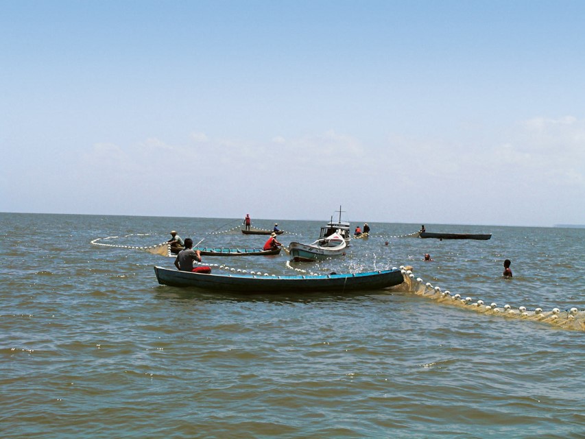
The large mouth-bay of the Lower Tocantins receives nutrients from the Rio Amazonas with the tidal inflow of water. Relatively high water transparency of the Rio Tocantins, in addition to nutrients from Rio Amazonas waters, supports relatively high phytop. Photographer: Michael Goulding
-

Bahía de las desembocaduras 2
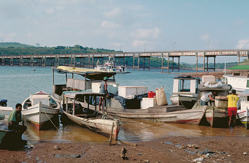
Type of commercial fishing boats used in the Tucuruí Dam reservoir. Fish is preserved in Styrofoam boxes. Ice lasts for only about 5-7 days in these boxes. Department – Country: Amazonas – Brazil Main Basin – Sub Basin: Negro – Lower Negro Main Stem Photographer: Michael Goulding
-

Bahía de las desembocaduras 3
Mapará catch in the Lower Tocantins mouth-bay. Photographer: Michael Goulding
CONTEXT
The Andes
Cataratas
Floodplain or Várzea
River Mouth Bays
River Channel
Estuary & Amazon Coast
Marajó and Inner Delta
