
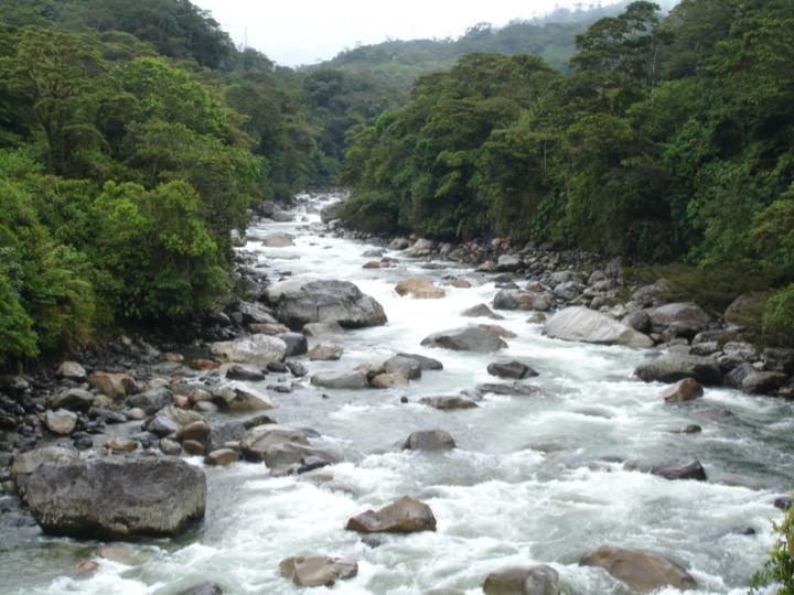
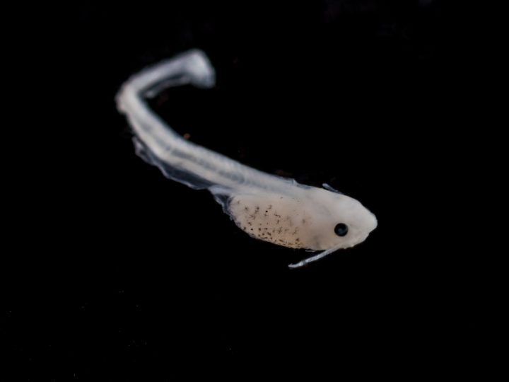
The Amazon Basin is home to more than 2000 fish species, each with unique characteristics. Among them are the “Goliath” catfish —which spend their lives migrating— a group of fish worth knowing about. The Amazon Basin also includes species that are important for the survival of many people in the Amazon: in many places, people eat up to 1 kg of fish per day, including catfish. Furthermore, this group of species has the longest migration or pilgrimage of all freshwater ecosystems. The gilded catfish (Brachyplatystoma rousseauxii) is born in or near the Andes and newborns migrate downstream until it reaches the Amazon River estuary where its nursery is located. In contrast, adults remain in the western Amazon for the rest of their lives, migrating yearly for short periods to spawn.
 Photo: Elizabeth Anderson.
But how much do we know about their migrations? As much as this group of fish is very important for the Amazon Basin, some of their migratory journeys are still a mystery, but thanks to a new scientific publication we know a little bit more. With hydrological data from stations, fishery data on migratory catfish in their reproductive state, fluviometric data acquired by satellite images, and climatic data, the researchers created a model that describes the relationships among this data and defines the depth of profiles required for spawning of the gilded catfish in the western Amazon. Thus, they found that spawning periods can be predicted by river depth: if the river depth above 250 m elevation is an average of 1.5 m, then catfish can migrate and spawn1.
With this information, we can think about what will happen in the future. Using climate models seven groups of basins with different migration regimes for catfish were identified, as well as how they will change under current climate change forecasts. Where there are no hydroelectric plants, climate change will bring forward and increase catfish migrations in the southern and southwestern basins (Madeira, Ucayali, Marañón, Juruá, and Purús), and will delay and decrease migrations in the northern and north-central basins (Caquetá-Japurá, Putumayo-Icá, Napo, and Blanco).

“Minimum depth (m) to catalyze fish migration and its associated uncertainty (m) for (a) historical periods and (b) future periods. The streams above the sixth level of the basin (Venticinque et al., 2016) where the study sites were found are in colored lines. Stream colors indicate minimum depth estimated at associated study sites. The dots are the study sites and the colors indicate the geographic location. The point sizes indicate the uncertainty in the minimum depth introduced by the geomorphological parameters. River depth rises with the drainage area; that is, the minimum depth upstream (downstream) is expected to be less (greater) than the values indicated in this figure. Different gray scales indicate the nine different major basins.”
This is a preliminary model that can be improved if we have more quality data. There are two ways to improve data: the first is by knowing more about where and when catfish are, and the second is by learning more about the fluviomorphology of the rivers where catfish live.
Data about the migratory catfish spawning used in this article comes from a single basin. With efforts like Ctizien Science for the Amazon, project, people who live and work in the basin area are making records of their fish caught and those seen in the market on the Ictio. app. In addition, organizations that have already been working on this issue can share databases through ictio.org. The objective of this type of project is precisely to expand the sources and the spatial scope of what we know about fish in the Amazon. Soon, these data points will inform us about the movement of migratory catfish, and provide what is necessary to adjust the model and see if the river depth truly predicts the movements of catfish in all of the basins.
 Photo: Elizabeth Anderson.
The study also identified that the greatest uncertainty in this model results was the lack of knowledge about river shapes (morphology), which is defined based on multiple variables that together have unique and emergent properties, such as the impact and shape of erosion and the path taken by the river, or the location and size of islands in the river. In the publication, this shape was defined based on satellite images, and where it could not be defined through satellite images, it was estimated using the mean of three published databases2. It was found out that the river cross-sectional shape and width were the variables most associated with uncertainty in this research. This type of data can be very difficult to collect as rivers change and satellite images do not always capture this dynamic at all. A project of the University of Engineering and Technology (UTEC), Rios Danzantes, is precisely making sure that the estimated data are correct, mixing remote monitoring methodologies (with drones) and data collection in the field. Thus, over time, here we will also find better data to improve models and better understand how catfish movements change.
Knowledge about “Goliath” catfish will continue to increase: their pilgrimages are mysterious, but if clarified, we will be able to make better decisions about our fishing, prioritizing the conservation, sustainable use, and maintenance of free rivers.
Written by Natalia Piland.
***
[1] This piece of data is an average. The range is <1 m to >5 m and seems to depend on how large the basin is. At the same time, there is geographic variation, where this depth is less in localities within the Madeira river basin, perhaps due to its lower rainfall.
[2] The databases are: Global Width Database for Large Rivers, South American River Width Dataset, and Beighley and Gummadi 2011.
